Geolocate

Cerceda topographic map

Click on the map to display elevation.

About this map
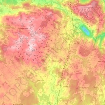
Name: Cerceda topographic map, elevation, terrain.

Location: Cerceda, Ordes, A Coruña, Galicia, Spain (43.09889 -8.59686 43.22652 -8.39606)

Average elevation: 1,194 ft

Minimum elevation: 62 ft

Maximum elevation: 1,939 ft

Other topographic maps

Click on a map to view its topography, its elevation and its terrain.
Hospital

Spain > Galicia > Ordes

Average elevation: 1,325 ft

O Canedo

Spain > Galicia > Ordes

Average elevation: 1,234 ft

Cruz de Nouche

Spain > Galicia > Ordes > Beán

Average elevation: 1,024 ft

Meitufe do Medio

Spain > Galicia > Ordes > Ordes

Average elevation: 1,257 ft

Gear up for your next adventure:

🌡️Portable Weather Meter - Track weather conditions on the trail
🪶Trail Camera - Capture wildlife on your hikes
🦶Carbon Trekking Poles - Reduce knee impact on steep descents with ultra-light poles
🥾Men's Hiking Boots - Durable, waterproof footwear for rugged terrain and steep inclines
📱Solar Portable Charger - Solar power bank for charging devices off‑grid

As an Amazon Associate, this site earns from qualifying purchases at no extra cost to you.