
Make a donation
Gear up for your next adventure:
As an Amazon Associate, this site earns from qualifying purchases at no extra cost to you.
Glaciar Grey topographic map
Click on the map to display elevation.
Make a donation
Gear up for your next adventure:
As an Amazon Associate, this site earns from qualifying purchases at no extra cost to you.
About this map
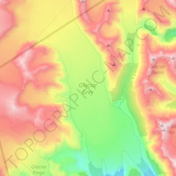
Name: Glaciar Grey topographic map, elevation, terrain.
Average elevation: 3,038 ft
Minimum elevation: 108 ft
Maximum elevation: 6,552 ft
Make a donation
Gear up for your next adventure:
As an Amazon Associate, this site earns from qualifying purchases at no extra cost to you.
Other topographic maps
Click on a map to view its topography, its elevation and its terrain.
Glaciar los Perros
Chile > Región de Magallanes y de la Antártica Chilena > Provincia de Última Esperanza > Torres del Paine
Average elevation: 4,423 ft
Mirador Nordenskjöld
Chile > Región de Magallanes y de la Antártica Chilena > Provincia de Última Esperanza > Torres del Paine
Average elevation: 354 ft
Mirador Cuernos
Chile > Región de Magallanes y de la Antártica Chilena > Provincia de Última Esperanza > Torres del Paine
Average elevation: 883 ft
Cerro Castillo
Chile > Región de Magallanes y de la Antártica Chilena > Provincia de Última Esperanza > Torres del Paine
Average elevation: 509 ft
Make a donation
Gear up for your next adventure:
As an Amazon Associate, this site earns from qualifying purchases at no extra cost to you.
Cerro Castillo
Chile > Región de Magallanes y de la Antártica Chilena > Provincia de Última Esperanza > Torres del Paine
Average elevation: 509 ft
Monte Almirante Nieto
Chile > Región de Magallanes y de la Antártica Chilena > Provincia de Última Esperanza > Torres del Paine
Average elevation: 6,473 ft
Cerro Castillo
Chile > Región de Magallanes y de la Antártica Chilena > Provincia de Última Esperanza > Torres del Paine
Average elevation: 509 ft