
Make a donation
Gear up for your next adventure:
As an Amazon Associate, this site earns from qualifying purchases at no extra cost to you.
Ochsenbach topographic map
Click on the map to display elevation.
Make a donation
Gear up for your next adventure:
As an Amazon Associate, this site earns from qualifying purchases at no extra cost to you.
Ochsenbach
Die Ortschaft selbst liegt auf einem Bergrücken zwischen Ochsenbach und Tannenbrunnenbächle, beides Nebenflüsse des in West-Ost-Richtung fließenden Kirbachs. Die Dorfstraße hat dabei eine Höhenlage von 275 m bis 290 m ü. NN, während der im Süden vorbeifließende Kirbach bei Ochsenbach eine Höhenlage von etwa 256 m ü. NN hat. Im Norden erhebt sich der Höhenzug des Strombergs bis auf über 410 m, die Passhöhe der L 1110 liegt auf 393 m ü. NN. Im Süden liegt der Höhenzug des Großen Brombergs mit dem 476,6 m hohen Gipfel des Baiselsbergs.
Make a donation
Gear up for your next adventure:
As an Amazon Associate, this site earns from qualifying purchases at no extra cost to you.
About this map
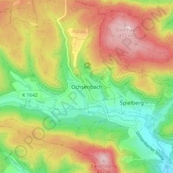
Name: Ochsenbach topographic map, elevation, terrain.
Average elevation: 1,132 ft
Minimum elevation: 758 ft
Maximum elevation: 1,558 ft
Make a donation
Gear up for your next adventure:
As an Amazon Associate, this site earns from qualifying purchases at no extra cost to you.
Other topographic maps
Click on a map to view its topography, its elevation and its terrain.
Spielberg
Deutschland > Baden-Württemberg > Landkreis Ludwigsburg > Sachsenheim
Average elevation: 1,040 ft
Häfnerhaslach
Deutschland > Baden-Württemberg > Landkreis Ludwigsburg > Sachsenheim
Average elevation: 1,102 ft
Hohenhaslach
Deutschland > Baden-Württemberg > Landkreis Ludwigsburg > Sachsenheim
Average elevation: 935 ft