
Make a donation
Gear up for your next adventure:
As an Amazon Associate, this site earns from qualifying purchases at no extra cost to you.
Selters topographic map
Click on the map to display elevation.
Make a donation
Gear up for your next adventure:
As an Amazon Associate, this site earns from qualifying purchases at no extra cost to you.
Selters
Selters liegt am Rande des westlichen Vogelsbergs auf einer Höhe von 147 m ü. NN, 2 km südwestlich des Zentrums von Ortenberg und 7,5 km nordwestlich von Büdingen.
Make a donation
Gear up for your next adventure:
As an Amazon Associate, this site earns from qualifying purchases at no extra cost to you.
About this map
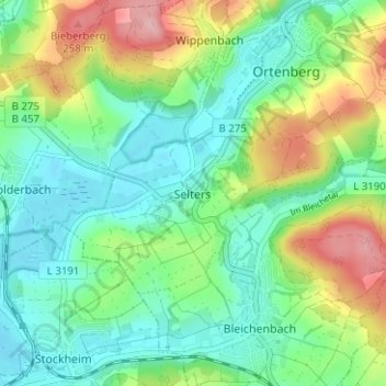
Name: Selters topographic map, elevation, terrain.
Location: Selters, Ortenberg, Wetteraukreis, Hessen, 63683, Deutschland (50.32096 9.01774 50.36096 9.05774)
Average elevation: 564 ft
Minimum elevation: 407 ft
Maximum elevation: 902 ft
Make a donation
Gear up for your next adventure:
As an Amazon Associate, this site earns from qualifying purchases at no extra cost to you.