
Make a donation
Gear up for your next adventure:
As an Amazon Associate, this site earns from qualifying purchases at no extra cost to you.
El Retorno topographic map
Click on the map to display elevation.
Make a donation
Gear up for your next adventure:
As an Amazon Associate, this site earns from qualifying purchases at no extra cost to you.
El Retorno
Tiene un área de 1017 kmª. Está conformado por 75 veredas, la cabecera municipal, 5 resguardos indígenas y 3 centros poblados. Se encuentra a una altitud de 245 m s. n. m., registrando una temperatura de 25 °C.
Make a donation
Gear up for your next adventure:
As an Amazon Associate, this site earns from qualifying purchases at no extra cost to you.
About this map
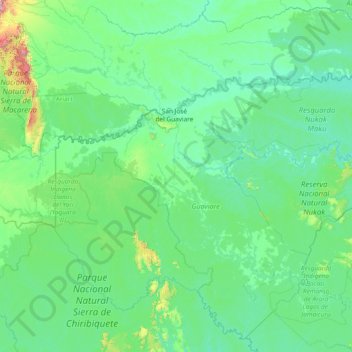
Name: El Retorno topographic map, elevation, terrain.
Location: El Retorno, Guaviare, RAP Amazonía, 951001, Colombia (1.66782 -72.99482 2.42571 -69.99453)
Average elevation: 801 ft
Minimum elevation: 443 ft
Maximum elevation: 6,375 ft
Make a donation
Gear up for your next adventure:
As an Amazon Associate, this site earns from qualifying purchases at no extra cost to you.
Other topographic maps
Click on a map to view its topography, its elevation and its terrain.
Make a donation
Gear up for your next adventure:
As an Amazon Associate, this site earns from qualifying purchases at no extra cost to you.
Reserva Forestal Protectora Serranía de La Lindosa
Colombia > Guaviare > San José del Guaviare
Average elevation: 722 ft
Vaupés
Colombia > Guaviare > Miraflores > Vereda Lagos del Dorado > Puerto Santander
Average elevation: 653 ft
Make a donation
Gear up for your next adventure:
As an Amazon Associate, this site earns from qualifying purchases at no extra cost to you.
Barranquillita
Colombia > Guaviare > Miraflores > Resguardo indígena Barranquillita
Average elevation: 679 ft
Make a donation
Gear up for your next adventure:
As an Amazon Associate, this site earns from qualifying purchases at no extra cost to you.
Barranquillita
Colombia > Guaviare > Miraflores > Resguardo indígena Barranquillita
Average elevation: 679 ft
Make a donation
Gear up for your next adventure:
As an Amazon Associate, this site earns from qualifying purchases at no extra cost to you.