
Make a donation
Gear up for your next adventure:
As an Amazon Associate, this site earns from qualifying purchases at no extra cost to you.
KuGompo City topographic map
Click on the map to display elevation.
Make a donation
Gear up for your next adventure:
As an Amazon Associate, this site earns from qualifying purchases at no extra cost to you.
About this map
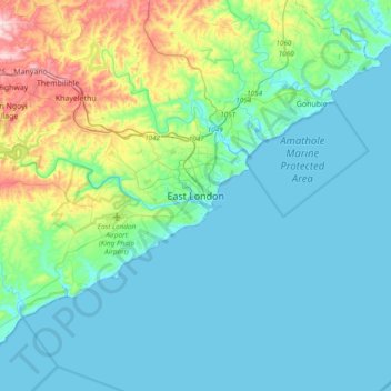
Name: KuGompo City topographic map, elevation, terrain.
Average elevation: 236 ft
Minimum elevation: -7 ft
Maximum elevation: 1,306 ft
Make a donation
Gear up for your next adventure:
As an Amazon Associate, this site earns from qualifying purchases at no extra cost to you.
Other topographic maps
Click on a map to view its topography, its elevation and its terrain.
Nahoon River
South Africa > Eastern Cape > Buffalo City Metropolitan Municipality > KuGompo City
Average elevation: 174 ft
Buffalo River
South Africa > Eastern Cape > Buffalo City Metropolitan Municipality
The Buffalo River has its source in the seeps and sponges of the Amatola Mountains at an altitude of 1200 m. The river is 126 kilometres long and drains a catchment of 1287 square kilometres. From its source, the river descends through indigenous forest in a deeply incised channel, flanked by rock cliffs up to…
Average elevation: 1,296 ft
Bridle Drift Dam
South Africa > Eastern Cape > Buffalo City Metropolitan Municipality > Zwelitsha
Average elevation: 764 ft
Buffalo City Ward 19
South Africa > Eastern Cape > Buffalo City Metropolitan Municipality > East London
Average elevation: 187 ft
Make a donation
Gear up for your next adventure:
As an Amazon Associate, this site earns from qualifying purchases at no extra cost to you.
Nahoon Dam
South Africa > Eastern Cape > Buffalo City Metropolitan Municipality
Average elevation: 581 ft
Buffalo City Ward 27
South Africa > Eastern Cape > Buffalo City Metropolitan Municipality
Average elevation: 472 ft
Nahoon River
South Africa > Eastern Cape > Buffalo City Metropolitan Municipality
Average elevation: 968 ft
Nahoon River
South Africa > Eastern Cape > Buffalo City Metropolitan Municipality > KuGompo City
Average elevation: 213 ft
Make a donation
Gear up for your next adventure:
As an Amazon Associate, this site earns from qualifying purchases at no extra cost to you.
Buffalo City Ward 22
South Africa > Eastern Cape > Buffalo City Metropolitan Municipality > Potsdam
Average elevation: 751 ft
King Williams Town Nature Reserve
South Africa > Eastern Cape > Buffalo City Metropolitan Municipality > Qonce
Average elevation: 1,581 ft
Nahoon River
South Africa > Eastern Cape > Buffalo City Metropolitan Municipality > East London
Average elevation: 174 ft
Buffalo River
South Africa > Eastern Cape > Buffalo City Metropolitan Municipality
The Buffalo River has its source in the seeps and sponges of the Amatola Mountains at an altitude of 1200 m. The river is 126 kilometres long and drains a catchment of 1287 square kilometres. From its source, the river descends through indigenous forest in a deeply incised channel, flanked by rock cliffs up to…
Average elevation: 1,296 ft
Make a donation
Gear up for your next adventure:
As an Amazon Associate, this site earns from qualifying purchases at no extra cost to you.
Nahoon River
South Africa > Eastern Cape > Buffalo City Metropolitan Municipality > East London
Average elevation: 174 ft