
Sagay topographic map
Click on the map to display elevation.
About this map
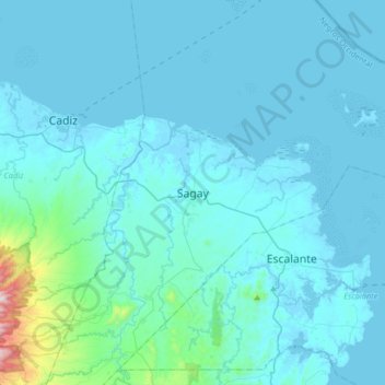
Name: Sagay topographic map, elevation, terrain.
Location: Sagay, Negros Occidental, Western Visayas, 6122, Philippines (10.73607 123.25546 11.05607 123.57546)
Average elevation: 210 ft
Minimum elevation: -13 ft
Maximum elevation: 3,136 ft
Other topographic maps
Click on a map to view its topography, its elevation and its terrain.