
İnkılap Mahallesi topographic map
Interactive map
Click on the map to display elevation.
About this map
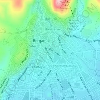
Name: İnkılap Mahallesi topographic map, elevation, terrain.
Location: İnkılap Mahallesi, Bergama, Izmir, Aegean Region, Turkey (39.11299 27.17831 39.12026 27.18533)
Average elevation: 259 ft
Minimum elevation: 108 ft
Maximum elevation: 906 ft
Other topographic maps
Click on a map to view its topography, its elevation and its terrain.
Talatpaşa Mahallesi
Talatpaşa Mahallesi, Bergama, Izmir, Aegean Region, Turkey
Average elevation: 367 ft
Gazipaşa Mahallesi
Gazipaşa Mahallesi, Bergama, Izmir, Aegean Region, Turkey
Average elevation: 335 ft