
Make a donation
Gear up for your next adventure:
As an Amazon Associate, this site earns from qualifying purchases at no extra cost to you.
Town of Inlet topographic map
Click on the map to display elevation.
Make a donation
Gear up for your next adventure:
As an Amazon Associate, this site earns from qualifying purchases at no extra cost to you.
About this map
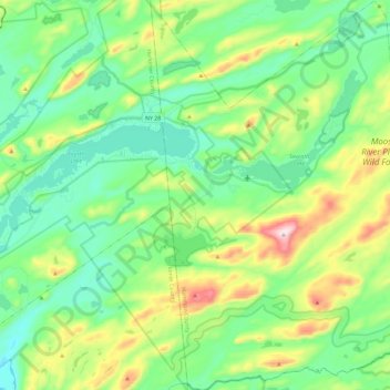
Name: Town of Inlet topographic map, elevation, terrain.
Average elevation: 1,969 ft
Minimum elevation: 1,601 ft
Maximum elevation: 2,871 ft
Hamilton County trails, hiking, mountain biking, running and outdoor activities
Make a donation
Gear up for your next adventure:
As an Amazon Associate, this site earns from qualifying purchases at no extra cost to you.
Other topographic maps
Click on a map to view its topography, its elevation and its terrain.
Handsome Pond
United States > New York > Hamilton County > Town of Long Lake
Average elevation: 1,926 ft
Big Bad Luck Pond
United States > New York > Hamilton County > Town of Indian Lake
Average elevation: 1,768 ft
Blue Mountain Lake
United States > New York > Hamilton County > Town of Indian Lake
Average elevation: 2,037 ft
Make a donation
Gear up for your next adventure:
As an Amazon Associate, this site earns from qualifying purchases at no extra cost to you.