
San Vicente topographic map
Interactive map
Click on the map to display elevation.
About this map
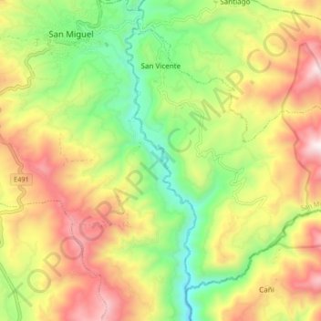
Name: San Vicente topographic map, elevation, terrain.
Location: San Vicente, San Miguel, Bolívar, Ecuador (-1.77476 -79.02781 -1.70718 -78.94492)
Average elevation: 8,625 ft
Minimum elevation: 7,024 ft
Maximum elevation: 10,522 ft
Other topographic maps
Click on a map to view its topography, its elevation and its terrain.
Guantugpamba
Ecuador > Bolívar > San Miguel > San Pablo de Atenas
Guantugpamba, San Pablo de Atenas, San Miguel, Bolívar, Ecuador
Average elevation: 8,953 ft
Guaboloma
Ecuador > Bolívar > San Miguel > San Miguel
Guaboloma, San Miguel, Bolívar, 020301, Ecuador
Average elevation: 8,363 ft
Los Ángeles
Ecuador > Bolívar > San Miguel > San Miguel
Los Ángeles, San Miguel, Bolívar, 020302, Ecuador
Average elevation: 8,064 ft
Santiago
Ecuador > Bolívar > San Miguel
Santiago, San Miguel, Bolívar, Ecuador
Average elevation: 9,360 ft
San Jose de las Palmas
Ecuador > Bolívar > San Miguel > San Pablo de Atenas
San Jose de las Palmas, San Pablo de Atenas, San Miguel, Bolívar, Ecuador
Average elevation: 8,855 ft
San Pablo de Atenas
Ecuador > Bolívar > San Miguel
San Pablo de Atenas, San Miguel, Bolívar, Ecuador
Average elevation: 7,920 ft