
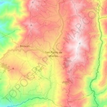
San Pablo de Atenas topographic map
Interactive map
Click on the map to display elevation.
About this map
Name: San Pablo de Atenas topographic map, elevation, terrain.
Location: San Pablo de Atenas, San Miguel, Bolívar, Ecuador (-1.88245 -79.12128 -1.75125 -79.03306)
Average elevation: 7,920 ft
Minimum elevation: 4,518 ft
Maximum elevation: 10,676 ft
Other topographic maps
Click on a map to view its topography, its elevation and its terrain.
Guantugpamba
Ecuador > Bolívar > San Miguel > San Pablo de Atenas
Guantugpamba, San Pablo de Atenas, San Miguel, Bolívar, Ecuador
Average elevation: 8,953 ft
Guaboloma
Ecuador > Bolívar > San Miguel > San Miguel
Guaboloma, San Miguel, Bolívar, 020301, Ecuador
Average elevation: 8,363 ft
Los Ángeles
Ecuador > Bolívar > San Miguel > San Miguel
Los Ángeles, San Miguel, Bolívar, 020302, Ecuador
Average elevation: 8,064 ft
San Vicente
Ecuador > Bolívar > San Miguel
San Vicente, San Miguel, Bolívar, Ecuador
Average elevation: 8,625 ft
Santiago
Ecuador > Bolívar > San Miguel
Santiago, San Miguel, Bolívar, Ecuador
Average elevation: 9,360 ft
San Jose de las Palmas
Ecuador > Bolívar > San Miguel > San Pablo de Atenas
San Jose de las Palmas, San Pablo de Atenas, San Miguel, Bolívar, Ecuador
Average elevation: 8,855 ft