Geolocate

Portinatx topographic map

Click on the map to display elevation.

About this map

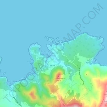
Name: Portinatx topographic map, elevation, terrain.

Location: Portinatx, Sant Joan de Labritja, Ibiza, Balearic Islands, Spain (39.09043 1.49813 39.13043 1.53813)

Average elevation: 138 ft

Minimum elevation: 0 ft

Maximum elevation: 909 ft

Other topographic maps

Click on a map to view its topography, its elevation and its terrain.

Ibiza

Spain > Balearic Islands > Ibiza

Average elevation: 171 ft

Sant Josep de sa Talaia

Spain > Balearic Islands > Ibiza

Average elevation: 180 ft

Cala Valdella

Spain > Balearic Islands > Ibiza

Average elevation: 184 ft

Gear up for your next adventure:

👟Men's Trail Runners - Lightweight footwear for fast-paced exploration and light hiking
🛰️Handheld GPS Units - Professional satellite navigators for precise backcountry mapping
⛑️Personal Locator Beacon - Safety beacon for emergencies
🌎3D Topographic Globes - Raised relief globes for a tactile understanding of geography
🔌Solar Panel Charger - Charge gear sustainably outdoors

As an Amazon Associate, this site earns from qualifying purchases at no extra cost to you.