
Make a donation
Gear up for your next adventure:
As an Amazon Associate, this site earns from qualifying purchases at no extra cost to you.
San Luis topographic map
Click on the map to display elevation.
Make a donation
Gear up for your next adventure:
As an Amazon Associate, this site earns from qualifying purchases at no extra cost to you.
San Luis
San Luis is generally rugged and mountainous. About 63% of its total land area is considered moderately high-to-high elevation highlands exceeding 500 metres (1,600 ft) above sea level. The rest of the area or 37% is less than 500 meters. The elevation ranges from 0 to 1,885 metres (6,184 ft) above sea level.
Make a donation
Gear up for your next adventure:
As an Amazon Associate, this site earns from qualifying purchases at no extra cost to you.
About this map
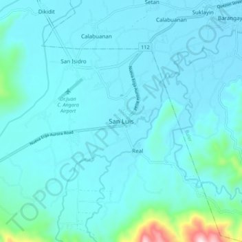
Name: San Luis topographic map, elevation, terrain.
Location: San Luis, Aurora, Central Luzon, 3201, Philippines (15.67912 121.47788 15.75912 121.55788)
Average elevation: 223 ft
Minimum elevation: 10 ft
Maximum elevation: 2,247 ft
Make a donation
Gear up for your next adventure:
As an Amazon Associate, this site earns from qualifying purchases at no extra cost to you.
Other topographic maps
Click on a map to view its topography, its elevation and its terrain.