
Thank you for supporting this site ❤️
Make a donation
Make a donation
Gear up for your next adventure:
As an Amazon Associate, this site earns from qualifying purchases at no extra cost to you.
Calore topographic map
Click on the map to display elevation.
Thank you for supporting this site ❤️
Make a donation
Make a donation
Gear up for your next adventure:
As an Amazon Associate, this site earns from qualifying purchases at no extra cost to you.
About this map
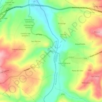
Name: Calore topographic map, elevation, terrain.
Location: Calore, Venticano, Avellino, Campania, 83036, Italia (41.03589 14.92437 41.07589 14.96437)
Average elevation: 863 ft
Minimum elevation: 600 ft
Maximum elevation: 1,165 ft
Thank you for supporting this site ❤️
Make a donation
Make a donation
Gear up for your next adventure:
As an Amazon Associate, this site earns from qualifying purchases at no extra cost to you.