
Make a donation
Gear up for your next adventure:
As an Amazon Associate, this site earns from qualifying purchases at no extra cost to you.
Woodward topographic map
Click on the map to display elevation.
Make a donation
Gear up for your next adventure:
As an Amazon Associate, this site earns from qualifying purchases at no extra cost to you.
Woodward
Woodward is located in northwestern Oklahoma, on the eastern edge of the Oklahoma and Texas panhandles. Its geographic coordinates are 36°25′59″N 99°23′52″W / 36.43306°N 99.39778°W / 36.43306; -99.39778 (36.433059, -99.397745) and its elevation is 1,906 feet (581 meters).
Make a donation
Gear up for your next adventure:
As an Amazon Associate, this site earns from qualifying purchases at no extra cost to you.
About this map
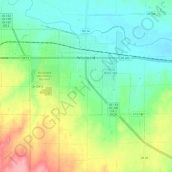
Name: Woodward topographic map, elevation, terrain.
Location: Woodward, Woodward County, Oklahoma, 73801, United States (36.39071 -99.46154 36.44795 -99.35378)
Average elevation: 1,995 ft
Minimum elevation: 1,860 ft
Maximum elevation: 2,274 ft
Woodward County trails, hiking, mountain biking, running and outdoor activities
Make a donation
Gear up for your next adventure:
As an Amazon Associate, this site earns from qualifying purchases at no extra cost to you.
Other topographic maps
Click on a map to view its topography, its elevation and its terrain.