
Make a donation
Gear up for your next adventure:
As an Amazon Associate, this site earns from qualifying purchases at no extra cost to you.
Blue Lake Township topographic map
Click on the map to display elevation.
Make a donation
Gear up for your next adventure:
As an Amazon Associate, this site earns from qualifying purchases at no extra cost to you.
About this map
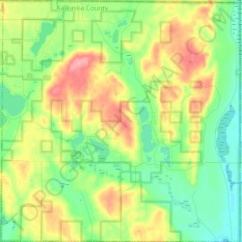
Name: Blue Lake Township topographic map, elevation, terrain.
Location: Blue Lake Township, Kalkaska County, Michigan, United States (44.77119 -84.96977 44.85898 -84.84732)
Average elevation: 1,273 ft
Minimum elevation: 1,152 ft
Maximum elevation: 1,463 ft
Kalkaska County trails, hiking, mountain biking, running and outdoor activities
Make a donation
Gear up for your next adventure:
As an Amazon Associate, this site earns from qualifying purchases at no extra cost to you.
Other topographic maps
Click on a map to view its topography, its elevation and its terrain.
Albright Swamp
United States > Michigan > Kalkaska County > South Boardman
Average elevation: 1,053 ft
Make a donation
Gear up for your next adventure:
As an Amazon Associate, this site earns from qualifying purchases at no extra cost to you.