
Thank you for supporting this site ❤️
Make a donation
Make a donation
Gear up for your next adventure:
As an Amazon Associate, this site earns from qualifying purchases at no extra cost to you.
Mero topographic map
Click on the map to display elevation.
Thank you for supporting this site ❤️
Make a donation
Make a donation
Gear up for your next adventure:
As an Amazon Associate, this site earns from qualifying purchases at no extra cost to you.
About this map
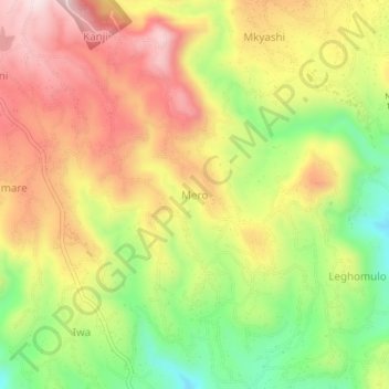
Name: Mero topographic map, elevation, terrain.
Location: Mero, Moshi Rural, Kilimangiaro, Northern Zone, Tanzania (-3.33432 37.45948 -3.29432 37.49948)
Average elevation: 4,701 ft
Minimum elevation: 3,940 ft
Maximum elevation: 5,397 ft
Thank you for supporting this site ❤️
Make a donation
Make a donation
Gear up for your next adventure:
As an Amazon Associate, this site earns from qualifying purchases at no extra cost to you.