Geolocate

Chapais topographic map

Click on the map to display elevation.

About this map

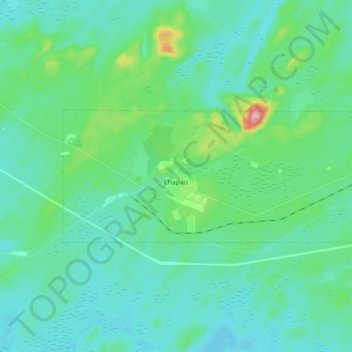
Name: Chapais topographic map, elevation, terrain.

Location: Chapais, Jamésie, Nord-du-Québec, Quebec, G0W 1H0, Canada (49.76285 -74.91543 49.80683 -74.73459)

Average elevation: 1,257 ft

Minimum elevation: 1,148 ft

Maximum elevation: 1,791 ft

Gear up for your next adventure:

💧Water Purification System - Clean water on the trail with reliable purifiers
🪑Portable Camp Table - Compact table for campsite meals
🕶️Glacier Sunglasses - Side shields to protect eyes from high-altitude snow glare
🗃️Trail First Aid Kit - Essential kit for outdoor injuries and emergencies
🥾Women's Hiking Boots - Top-rated trail boots with ankle support and superior grip

As an Amazon Associate, this site earns from qualifying purchases at no extra cost to you.