Geolocate

Badapur topographic map

Click on the map to display elevation.

About this map

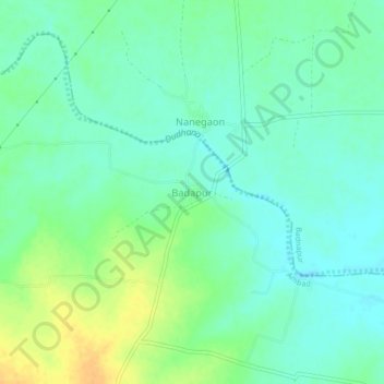
Name: Badapur topographic map, elevation, terrain.

Location: Badapur, Ambad, Jalna, Maharashtra, India (19.73890 75.70135 19.77890 75.74135)

Average elevation: 1,627 ft

Minimum elevation: 1,591 ft

Maximum elevation: 1,690 ft

Gear up for your next adventure:

🔌Solar Panel Charger - Charge gear sustainably outdoors
🔥Camping Stove - Portable stove for camping and backcountry cooking
🌡️Handheld Weather Meters - Measure wind, temp, and pressure for safe mountain travel
🎒Trail Energy Bars - High‑calorie bars for hiking energy
🌲Outdoor Survival Books - Best books on survival skills

As an Amazon Associate, this site earns from qualifying purchases at no extra cost to you.