Geolocate

Mount Oro topographic map

Click on the map to display elevation.

About this map

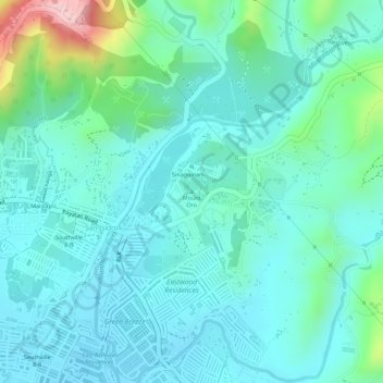
Name: Mount Oro topographic map, elevation, terrain.

Location: Mount Oro, Montalban, Rizal, Calabarzon, 1860, Philippines (14.77653 121.18534 14.77663 121.18544)

Average elevation: 564 ft

Minimum elevation: 164 ft

Maximum elevation: 1,329 ft

Other topographic maps

Click on a map to view its topography, its elevation and its terrain.

Wawa Dam

Philippines > Rizal > Montalban > Wawa > Inigan

Average elevation: 512 ft

Upper Wawa Dam

Philippines > Rizal > Montalban

Average elevation: 610 ft

Gear up for your next adventure:

🥤Water Filter Bottle - All‑in‑one filter bottle for safe hydration
🔦Compact Flashlight - Reliable flashlight for emergencies
🥘Titanium Cookware - Durable, featherlight pots and pans for backpacking
🪶Multi‑Purpose Knife - Useful blade for camp and trail
Backpacking Tents - Weight-optimized shelters for multi-day topographic surveys

As an Amazon Associate, this site earns from qualifying purchases at no extra cost to you.