Geolocate

Straß topographic map

Click on the map to display elevation.

About this map

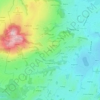
Name: Straß topographic map, elevation, terrain.

Location: Straß, Bernbeuren, Bernbeuren (VGem), Landkreis Weilheim-Schongau, Bayern, 86975, Deutschland (47.70891 10.73809 47.74891 10.77809)

Average elevation: 2,733 ft

Minimum elevation: 2,438 ft

Maximum elevation: 3,438 ft

Other topographic maps

Click on a map to view its topography, its elevation and its terrain.

Stenz

Deutschland > Bayern > Landkreis Weilheim-Schongau > Bernbeuren

Average elevation: 2,523 ft

Gear up for your next adventure:

🎁Geography Themed Gifts - Unique gift ideas for map lovers and geography enthusiasts
📻Weather Alert Radios - Stay informed of storm risks while off-the-grid
🪶LED Camping Lantern - Bright lantern for camp lighting
🧣Merino Neck Gaiters - Multi-functional headwear for wind and sun protection
📦Gear Storage Bags - Organize and protect outdoor equipment

As an Amazon Associate, this site earns from qualifying purchases at no extra cost to you.