Geolocate

Lac Monahan topographic map

Click on the map to display elevation.

About this map

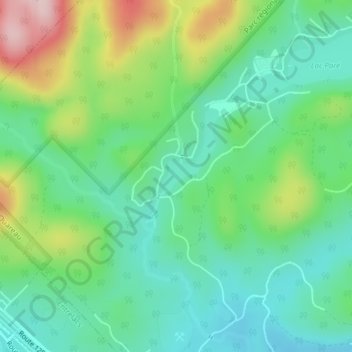
Name: Lac Monahan topographic map, elevation, terrain.

Location: Lac Monahan, Chertsey, Matawinie, Lanaudière, Québec, Canada (46.14303 -73.94898 46.14540 -73.94483)

Average elevation: 1,273 ft

Minimum elevation: 1,001 ft

Maximum elevation: 1,877 ft

Other topographic maps

Click on a map to view its topography, its elevation and its terrain.

Lac Grenier

Canada > Québec > Matawinie > Chertsey

Average elevation: 1,125 ft

Lac Beaulne

Canada > Québec > Matawinie > Chertsey

Average elevation: 1,198 ft

9e Lac

Canada > Québec > Matawinie > Chertsey

Average elevation: 1,033 ft

Lac Beaulac

Canada > Québec > Matawinie > Chertsey > Notre-Dame-de-Beaulac

Average elevation: 1,112 ft

Lac Lafond

Canada > Québec > Matawinie > Chertsey

Average elevation: 1,119 ft

Lac-David

Canada > Québec > Matawinie > Chertsey

Average elevation: 1,207 ft

Rivière Jean-Venne

Canada > Québec > Matawinie > Chertsey

Average elevation: 1,178 ft

Lac Taillefer

Canada > Québec > Matawinie > Chertsey

Average elevation: 1,027 ft

Mont Tête-Dure

Canada > Québec > Matawinie > Chertsey

Average elevation: 1,709 ft

Gear up for your next adventure:

🛠️Outdoor Gear Repair Kit - Essential tools to fix gear on the trail
❄️Traction Cleats - Prevent slips on icy trails during winter hikes
Solar GPS Watches - Advanced multisport watches with built-in topographic maps
🛡️Insect Repellent - Protection against bugs during outdoor activities
📚USA Hiking Guide Books - Top trail guides and map books

As an Amazon Associate, this site earns from qualifying purchases at no extra cost to you.