
Make a donation
Gear up for your next adventure:
As an Amazon Associate, this site earns from qualifying purchases at no extra cost to you.
Hopewell topographic map
Click on the map to display elevation.
Make a donation
Gear up for your next adventure:
As an Amazon Associate, this site earns from qualifying purchases at no extra cost to you.
About this map
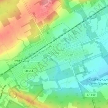
Name: Hopewell topographic map, elevation, terrain.
Location: Hopewell, Mercer County, New Jersey, 08525, United States (40.38112 -74.77742 40.39686 -74.75141)
Average elevation: 240 ft
Minimum elevation: 125 ft
Maximum elevation: 430 ft
Mercer County trails, hiking, mountain biking, running and outdoor activities
Make a donation
Gear up for your next adventure:
As an Amazon Associate, this site earns from qualifying purchases at no extra cost to you.
Other topographic maps
Click on a map to view its topography, its elevation and its terrain.
Twin Rivers
United States > New Jersey > Mercer County > East Windsor Township
Average elevation: 115 ft
Braeburn Heights
United States > New Jersey > Mercer County > Ewing Township
Average elevation: 112 ft
Make a donation
Gear up for your next adventure:
As an Amazon Associate, this site earns from qualifying purchases at no extra cost to you.
Make a donation
Gear up for your next adventure:
As an Amazon Associate, this site earns from qualifying purchases at no extra cost to you.
Harneys Corner
United States > New Jersey > Mercer County > Lawrence Township
Average elevation: 85 ft
Rosedale Park
United States > New Jersey > Mercer County > Hopewell Township
Average elevation: 184 ft
Make a donation
Gear up for your next adventure:
As an Amazon Associate, this site earns from qualifying purchases at no extra cost to you.
Princeton Colonial Park
United States > New Jersey > Mercer County > Princeton Colonial Park
Average elevation: 95 ft
Hamilton Square
United States > New Jersey > Mercer County > Hamilton Township > Hamilton Square
Average elevation: 95 ft
Make a donation
Gear up for your next adventure:
As an Amazon Associate, this site earns from qualifying purchases at no extra cost to you.
Chewalla Park
United States > New Jersey > Mercer County > Hamilton Township > Chewalla Park
Average elevation: 69 ft
Van Nest Park
United States > New Jersey > Mercer County > West Windsor > Old Mill Farms
Average elevation: 89 ft
Make a donation
Gear up for your next adventure:
As an Amazon Associate, this site earns from qualifying purchases at no extra cost to you.