
Make a donation
Gear up for your next adventure:
As an Amazon Associate, this site earns from qualifying purchases at no extra cost to you.
Howald topographic map
Click on the map to display elevation.
Make a donation
Gear up for your next adventure:
As an Amazon Associate, this site earns from qualifying purchases at no extra cost to you.
About this map
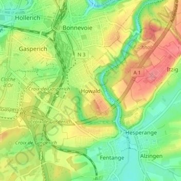
Name: Howald topographic map, elevation, terrain.
Location: Howald, Hesperange, Canton Luxembourg, 1749, Luxembourg (49.56215 6.12436 49.60215 6.16436)
Average elevation: 958 ft
Minimum elevation: 830 ft
Maximum elevation: 1,112 ft
Make a donation
Gear up for your next adventure:
As an Amazon Associate, this site earns from qualifying purchases at no extra cost to you.
Other topographic maps
Click on a map to view its topography, its elevation and its terrain.
Contern
Luxembourg > Canton Luxembourg
Contern lies within the Guttland region of Luxembourg and covers part of both the Luxembourg Plateau and Moselle Valley sub-regions. The contrast between the two sub regions gives Contern a varying topography, from the rolling hills in the south, north and west to the sharp sandstone cliffs to the east around…
Average elevation: 1,007 ft
Make a donation
Gear up for your next adventure:
As an Amazon Associate, this site earns from qualifying purchases at no extra cost to you.