
Make a donation
Gear up for your next adventure:
As an Amazon Associate, this site earns from qualifying purchases at no extra cost to you.
Hatiheu topographic map
Click on the map to display elevation.
Make a donation
Gear up for your next adventure:
As an Amazon Associate, this site earns from qualifying purchases at no extra cost to you.
About this map
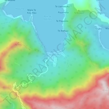
Name: Hatiheu topographic map, elevation, terrain.
Average elevation: 748 ft
Minimum elevation: 0 ft
Maximum elevation: 2,536 ft
Make a donation
Gear up for your next adventure:
As an Amazon Associate, this site earns from qualifying purchases at no extra cost to you.
Other topographic maps
Click on a map to view its topography, its elevation and its terrain.
Eiao
France > Polynésie française > Îles Marquises > Nuku Hiva
Le centre d’Eiao est un plateau élevé, à l’altitude comprise entre 300 et 500 mètres, incliné vers le nord-ouest et bordé au sud par de hautes falaises côtières. Son point culminant est le Moukatiketike, qui s'élève à 578 mètres tandis que le Tohuanui est à 550 mètres.
Average elevation: 302 ft