
Thank you for supporting this site ❤️
Make a donation
Make a donation
Gear up for your next adventure:
As an Amazon Associate, this site earns from qualifying purchases at no extra cost to you.
Tetu topographic map
Click on the map to display elevation.
Thank you for supporting this site ❤️
Make a donation
Make a donation
Gear up for your next adventure:
As an Amazon Associate, this site earns from qualifying purchases at no extra cost to you.
About this map
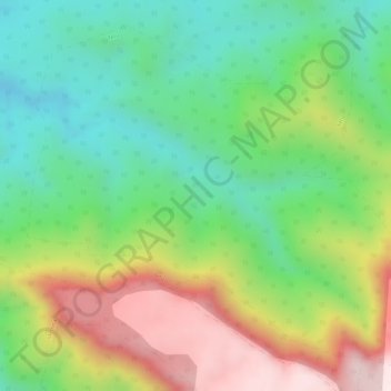
Name: Tetu topographic map, elevation, terrain.
Location: Tetu, Chikhaldara, Amravati, Maharashtra, India (21.44017 77.32538 21.46371 77.35321)
Average elevation: 2,618 ft
Minimum elevation: 1,985 ft
Maximum elevation: 3,501 ft
Thank you for supporting this site ❤️
Make a donation
Make a donation
Gear up for your next adventure:
As an Amazon Associate, this site earns from qualifying purchases at no extra cost to you.