
Thank you for supporting this site ❤️
Make a donation
Make a donation
Gear up for your next adventure:
As an Amazon Associate, this site earns from qualifying purchases at no extra cost to you.
Warthof topographic map
Click on the map to display elevation.
Thank you for supporting this site ❤️
Make a donation
Make a donation
Gear up for your next adventure:
As an Amazon Associate, this site earns from qualifying purchases at no extra cost to you.
About this map
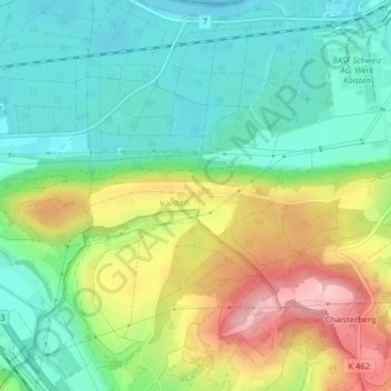
Name: Warthof topographic map, elevation, terrain.
Location: Warthof, Kaisten, Bezirk Laufenburg, Aargau, 5072, Schweiz (47.52720 8.00879 47.54720 8.02879)
Average elevation: 1,211 ft
Minimum elevation: 965 ft
Maximum elevation: 1,650 ft
Thank you for supporting this site ❤️
Make a donation
Make a donation
Gear up for your next adventure:
As an Amazon Associate, this site earns from qualifying purchases at no extra cost to you.