
Thank you for supporting this site ❤️
Make a donation
Make a donation
Gear up for your next adventure:
As an Amazon Associate, this site earns from qualifying purchases at no extra cost to you.
Malyovitsa topographic map
Click on the map to display elevation.
Thank you for supporting this site ❤️
Make a donation
Make a donation
Gear up for your next adventure:
As an Amazon Associate, this site earns from qualifying purchases at no extra cost to you.
About this map
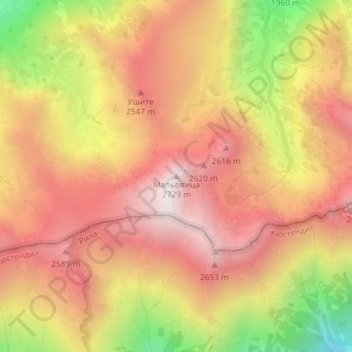
Name: Malyovitsa topographic map, elevation, terrain.
Location: Malyovitsa, Samokov, Sofia, Bulgaria (42.17377 23.36297 42.17387 23.36307)
Average elevation: 7,703 ft
Minimum elevation: 5,725 ft
Maximum elevation: 8,930 ft
Thank you for supporting this site ❤️
Make a donation
Make a donation
Gear up for your next adventure:
As an Amazon Associate, this site earns from qualifying purchases at no extra cost to you.