Geolocate

Lottah topographic map

Click on the map to display elevation.

About this map

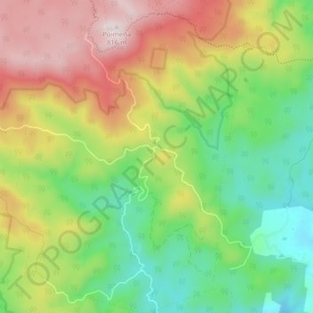
Name: Lottah topographic map, elevation, terrain.

Location: Lottah, Break O'Day, Tasmania, Australia (-41.25189 147.98454 -41.19330 148.04448)

Average elevation: 1,378 ft

Minimum elevation: 469 ft

Maximum elevation: 2,661 ft

Other topographic maps

Click on a map to view its topography, its elevation and its terrain.

Cathedral Mountain

Australia > Tasmania

Average elevation: 3,255 ft

The Nut

Australia > Tasmania > Stanley

Average elevation: 26 ft

Waterworks Reserve

Australia > Tasmania > Hobart

Average elevation: 787 ft

Rowlands Hill

Australia > Tasmania

Average elevation: 1,273 ft

Bream Creek

Australia > Tasmania > Bream Creek

Average elevation: 115 ft

Cradle Mountain

Australia > Tasmania > Cradle Mountain

Average elevation: 3,753 ft

West Gawler River

Australia > Tasmania > Sprent > Gawler

Average elevation: 659 ft

Mount Patrick

Australia > Tasmania

Average elevation: 2,831 ft

Mount Tyndall

Australia > Tasmania

Average elevation: 2,986 ft

Mount Ossa

Australia > Tasmania

Average elevation: 3,996 ft

Gear up for your next adventure:

🧭Orienteering Set - Complete compass and map reading kit
🎒Trail Energy Bars - High‑calorie bars for hiking energy
🖼️Topo Map Wall Art - Decorative topographic prints of famous peaks and regions
🛡️Bear Spray Outdoor - Protection in bear country hikes
🛠️Backpacking Tool Kit - Essential toolkit for outdoor repairs

As an Amazon Associate, this site earns from qualifying purchases at no extra cost to you.