
Thank you for supporting this site ❤️
Make a donation
Make a donation
Gear up for your next adventure:
As an Amazon Associate, this site earns from qualifying purchases at no extra cost to you.
Lagoa topographic map
Click on the map to display elevation.
Thank you for supporting this site ❤️
Make a donation
Make a donation
Gear up for your next adventure:
As an Amazon Associate, this site earns from qualifying purchases at no extra cost to you.
About this map
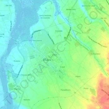
Name: Lagoa topographic map, elevation, terrain.
Location: Lagoa, Ílhavo (São Salvador), Ílhavo, Aveiro, 3830, Portugal (40.58196 -8.68302 40.62196 -8.64302)
Average elevation: 56 ft
Minimum elevation: -16 ft
Maximum elevation: 177 ft
Thank you for supporting this site ❤️
Make a donation
Make a donation
Gear up for your next adventure:
As an Amazon Associate, this site earns from qualifying purchases at no extra cost to you.
Other topographic maps
Click on a map to view its topography, its elevation and its terrain.
Praia da Costa Nova
Portugal > Aveiro > Ílhavo > Gafanha da Encarnação > Costa Nova
Average elevation: 3 ft