
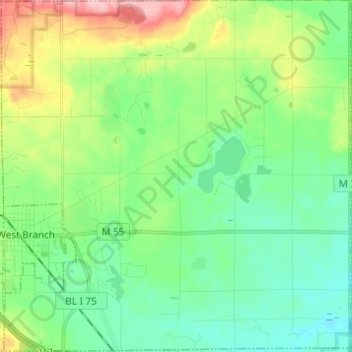
West Branch Township topographic map
Interactive map
Click on the map to display elevation.
About this map
Name: West Branch Township topographic map, elevation, terrain.
Average elevation: 968 ft
Minimum elevation: 814 ft
Maximum elevation: 1,342 ft
Other topographic maps
Click on a map to view its topography, its elevation and its terrain.
South Branch
United States > Michigan > Ogemaw County
South Branch, Goodar Township, Ogemaw County, Michigan, 48743, United States
Average elevation: 932 ft
West Branch
United States > Michigan > Ogemaw County
West Branch, Ogemaw County, Michigan, United States
Average elevation: 965 ft
Skidway Lake
United States > Michigan > Ogemaw County
Skidway Lake, Mills Township, Ogemaw County, Michigan, 48756, United States
Average elevation: 801 ft
Lupton
United States > Michigan > Ogemaw County
Lupton, Rose Township, Ogemaw County, Michigan, United States
Average elevation: 945 ft
Rose Township
United States > Michigan > Ogemaw County
Rose Township, Ogemaw County, Michigan, 48654, United States
Average elevation: 1,155 ft
Mills Township
United States > Michigan > Ogemaw County
Mills Township, Ogemaw County, Michigan, 48756, United States
Average elevation: 810 ft
Logan Township
United States > Michigan > Ogemaw County
Logan Township, Ogemaw County, Michigan, United States
Average elevation: 853 ft
West Branch
United States > Michigan > Ogemaw County
West Branch, Mills Township, Ogemaw County, Michigan, United States
Average elevation: 820 ft