Geolocate

West Branch topographic map

Click on the map to display elevation.

About this map

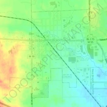
Name: West Branch topographic map, elevation, terrain.

Location: West Branch, Ogemaw County, Michigan, United States (44.26185 -84.25415 44.28412 -84.22115)

Average elevation: 965 ft

Minimum elevation: 899 ft

Maximum elevation: 1,056 ft

Ogemaw County trails, hiking, mountain biking, running and outdoor activities

Other topographic maps

Click on a map to view its topography, its elevation and its terrain.

Long Lost Lake

United States > Michigan > Ogemaw County

Average elevation: 1,270 ft

Gear Lake

United States > Michigan > Ogemaw County > Edwards Township

Average elevation: 1,037 ft

Muleshoe Lake

United States > Michigan > Ogemaw County > Rose Township

Average elevation: 1,319 ft

Ambrose Lake

United States > Michigan > Ogemaw County

Average elevation: 1,283 ft

Gear up for your next adventure:

📦Gear Storage Bags - Organize and protect outdoor equipment
🕶️GPS Smartphone Mount - Secure mount for phone navigation
🎁Geography Themed Gifts - Unique gift ideas for map lovers and geography enthusiasts
🧣Merino Neck Gaiters - Multi-functional headwear for wind and sun protection
🧯Portable Fire Pit - Compact fire pit for camping spots

As an Amazon Associate, this site earns from qualifying purchases at no extra cost to you.