
Thank you for supporting this site ❤️
Make a donation
Make a donation
Gear up for your next adventure:
As an Amazon Associate, this site earns from qualifying purchases at no extra cost to you.
Guraiya topographic map
Click on the map to display elevation.
Thank you for supporting this site ❤️
Make a donation
Make a donation
Gear up for your next adventure:
As an Amazon Associate, this site earns from qualifying purchases at no extra cost to you.
About this map
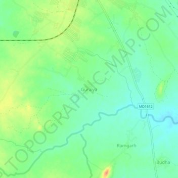
Name: Guraiya topographic map, elevation, terrain.
Location: Guraiya, Chhatarpur Tahsil, Chhatarpur, Madhya Pradesh, India (24.82884 79.57887 24.86884 79.61887)
Average elevation: 1,004 ft
Minimum elevation: 951 ft
Maximum elevation: 1,093 ft
Thank you for supporting this site ❤️
Make a donation
Make a donation
Gear up for your next adventure:
As an Amazon Associate, this site earns from qualifying purchases at no extra cost to you.