
Make a donation
Gear up for your next adventure:
As an Amazon Associate, this site earns from qualifying purchases at no extra cost to you.
Thornhurst topographic map
Click on the map to display elevation.
Make a donation
Gear up for your next adventure:
As an Amazon Associate, this site earns from qualifying purchases at no extra cost to you.
About this map
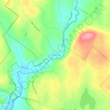
Name: Thornhurst topographic map, elevation, terrain.
Average elevation: 1,660 ft
Minimum elevation: 1,493 ft
Maximum elevation: 1,890 ft
Lackawanna County trails, hiking, mountain biking, running and outdoor activities
Make a donation
Gear up for your next adventure:
As an Amazon Associate, this site earns from qualifying purchases at no extra cost to you.
Other topographic maps
Click on a map to view its topography, its elevation and its terrain.
Big Bass Lake
United States > Pennsylvania > Lackawanna County > Clifton Township
Average elevation: 1,873 ft
Moosic Lakes
United States > Pennsylvania > Lackawanna County > Jefferson Township
Average elevation: 2,018 ft
Make a donation
Gear up for your next adventure:
As an Amazon Associate, this site earns from qualifying purchases at no extra cost to you.
Moosic Lakes
United States > Pennsylvania > Lackawanna County > Jefferson Township
Average elevation: 2,024 ft
Make a donation
Gear up for your next adventure:
As an Amazon Associate, this site earns from qualifying purchases at no extra cost to you.
Crystal Lake
United States > Pennsylvania > Lackawanna County > Clifford Township
Average elevation: 1,729 ft
Lake Hide Away
United States > Pennsylvania > Lackawanna County > Moscow > Harmony Hills
Average elevation: 1,699 ft
Make a donation
Gear up for your next adventure:
As an Amazon Associate, this site earns from qualifying purchases at no extra cost to you.