
Inukjuak (Village) topographic map
Interactive map
Click on the map to display elevation.
About this map
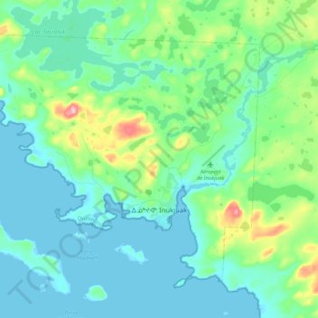
Name: Inukjuak (Village) topographic map, elevation, terrain.
Location: Inukjuak (Village), Kativik, Nord-du-Québec, Quebec, Canada (58.42695 -78.25490 58.51353 -78.04690)
Average elevation: 95 ft
Minimum elevation: -3 ft
Maximum elevation: 486 ft
Other topographic maps
Click on a map to view its topography, its elevation and its terrain.
Kuujjuarapik (Village)
Kuujjuarapik (Village), Kativik, Nord-du-Québec, Quebec, Canada
Average elevation: 59 ft
Kuujjuaq (Village)
Kuujjuaq (Village), Kativik, Nord-du-Québec, Quebec, Canada
Average elevation: 210 ft
Lac La Potherie
Canada > Quebec > Kativik > Rivière-Koksoak
Lac La Potherie, Rivière-Koksoak, Kativik, Nord-du-Québec, Quebec, Canada
Average elevation: 725 ft
Kangiqsujuaq (Village)
Kangiqsujuaq (Village), Kativik, Northern Quebec, Quebec, Canada
Average elevation: 351 ft
Wiyâshâkimî Lake
Wiyâshâkimî Lake, Kativik, Northern Quebec, Quebec, Canada
Average elevation: 883 ft
Baie-d'Hudson
Baie-d'Hudson, Kativik, Nord-du-Québec, Quebec, Canada
Average elevation: 443 ft
Tasiujaq (Village)
Tasiujaq (Village), Kativik, Nord-du-Québec, Quebec, Canada
Average elevation: 118 ft
Kangiqsualujjuaq (Village)
Kangiqsualujjuaq (Village), Kativik, Nord-du-Québec, Quebec, Canada
Average elevation: 259 ft
Rivière-Koksoak
Rivière-Koksoak, Kativik, Nord-du-Québec, Quebec, Canada
Average elevation: 630 ft
Ungava Peninsula
Canada > Quebec > Kativik > Baie-d'Hudson
Ungava Peninsula, Baie-d'Hudson, Kativik, Northern Quebec, Quebec, Canada
Average elevation: 1,161 ft