
Parroquia Altagracia topographic map
Interactive map
Click on the map to display elevation.
About this map
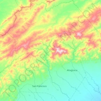
Name: Parroquia Altagracia topographic map, elevation, terrain.
Average elevation: 2,408 ft
Minimum elevation: 1,358 ft
Maximum elevation: 4,570 ft
Other topographic maps
Click on a map to view its topography, its elevation and its terrain.
Carora
Venezuela > Estado Lara > Municipio Torres
Carora, Parroquia Trinidad Samuel, Municipio Torres, Estado Lara, Venezuela
Average elevation: 1,634 ft
Altagracia
Venezuela > Estado Lara > Municipio Torres
Altagracia, Parroquia Altagracia, Municipio Torres, Estado Lara, Venezuela
Average elevation: 1,736 ft