Geolocate

Carora topographic map

Click on the map to display elevation.

Carora

Su límite municipal se localiza por el norte con el Estado Falcón y el Municipio Urdaneta, por el sur con el Municipio Morán y el Estado Trujillo, por el este con los Municipio Jiménez e Iribarren y por el oeste con el Estado Zulia. Tiene una altitud de 10 m.s.n.m en la Urbanización La Represa, 419 m.s.n.m en la Plaza Bolívar y de 1200 m.s.n.m en El Mirador del sector aledaño San Pedro.

Wikipedia (CC-BY-SA 3.0)

About this map

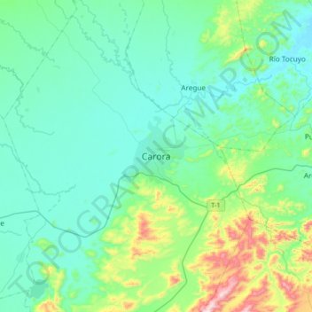
Name: Carora topographic map, elevation, terrain.

Location: Carora, Parroquia Trinidad Samuel, Municipio Torres, Venezuela (10.00953 -70.23285 10.32953 -69.91285)

Average elevation: 1,634 ft

Minimum elevation: 1,247 ft

Maximum elevation: 3,386 ft

Other topographic maps

Click on a map to view its topography, its elevation and its terrain.

Quebrada San Cristóbal

Venezuela > Municipio Torres > Aregue

Average elevation: 1,473 ft

Gear up for your next adventure:

🚗GPS Dash Cams - Record your scenic drives through mountain passes and canyons
🪑Ultralight Camp Chairs - Portable seating for resting after a long day of mapping
🥤Water Filter Bottle - All‑in‑one filter bottle for safe hydration
🧴Hand Sanitizer - Keep hands clean while hiking
Solar GPS Watches - Advanced multisport watches with built-in topographic maps

As an Amazon Associate, this site earns from qualifying purchases at no extra cost to you.