
Make a donation
Gear up for your next adventure:
As an Amazon Associate, this site earns from qualifying purchases at no extra cost to you.
Ìsili/Isili topographic map
Click on the map to display elevation.
Make a donation
Gear up for your next adventure:
As an Amazon Associate, this site earns from qualifying purchases at no extra cost to you.
About this map
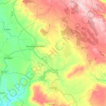
Name: Ìsili/Isili topographic map, elevation, terrain.
Location: Ìsili/Isili, Casteddu/Cagliari, Sardinia, 08033, Italy (39.71814 9.07203 39.84572 9.18005)
Average elevation: 1,699 ft
Minimum elevation: 646 ft
Maximum elevation: 2,920 ft
Make a donation
Gear up for your next adventure:
As an Amazon Associate, this site earns from qualifying purchases at no extra cost to you.
Other topographic maps
Click on a map to view its topography, its elevation and its terrain.
Salmagi
Italy > Sardinia > Casteddu/Cagliari > Quartu Sant'Aleni/Quartu Sant'Elena > Terra Mala
Average elevation: 197 ft
Monte Arcosu
Italy > Sardinia > Casteddu/Cagliari > Siliqua
Monte Arcosu is a mountain in the Sulcis massif, in southern Sardinia, Italy. It has an elevation of 948 metres (3,110 ft).
Average elevation: 1,791 ft
Make a donation
Gear up for your next adventure:
As an Amazon Associate, this site earns from qualifying purchases at no extra cost to you.