
Thank you for supporting this site ❤️
Make a donation
Make a donation
Gear up for your next adventure:
As an Amazon Associate, this site earns from qualifying purchases at no extra cost to you.
Binakot topographic map
Click on the map to display elevation.
Thank you for supporting this site ❤️
Make a donation
Make a donation
Gear up for your next adventure:
As an Amazon Associate, this site earns from qualifying purchases at no extra cost to you.
About this map
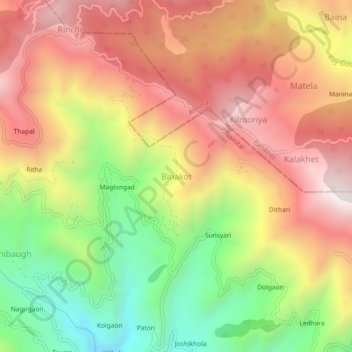
Name: Binakot topographic map, elevation, terrain.
Location: Binakot, Betalghat, Nainital, Uttarakhand, 263663, India (29.57281 79.32623 29.61281 79.36623)
Average elevation: 4,957 ft
Minimum elevation: 3,146 ft
Maximum elevation: 6,522 ft
Thank you for supporting this site ❤️
Make a donation
Make a donation
Gear up for your next adventure:
As an Amazon Associate, this site earns from qualifying purchases at no extra cost to you.