Geolocate

Siletz topographic map

Click on the map to display elevation.

About this map

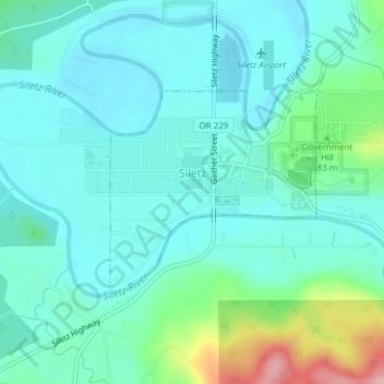
Name: Siletz topographic map, elevation, terrain.

Location: Siletz, Lincoln County, Oregon, 97380, United States (44.71324 -123.92831 44.72761 -123.90770)

Average elevation: 174 ft

Minimum elevation: 59 ft

Maximum elevation: 630 ft

Lincoln County trails, hiking, mountain biking, running and outdoor activities

Other topographic maps

Click on a map to view its topography, its elevation and its terrain.

Otter Rock

United States > Oregon > Lincoln County

Average elevation: 20 ft

Seal Rock

United States > Oregon > Lincoln County

Average elevation: 20 ft

Bayshore

United States > Oregon > Lincoln County

Average elevation: 49 ft

Tidewater

United States > Oregon > Lincoln County

Average elevation: 728 ft

Beverly Beach

United States > Oregon > Lincoln County

Average elevation: 95 ft

Logsden

United States > Oregon > Lincoln County

Average elevation: 390 ft

Eddyville

United States > Oregon > Lincoln County

Average elevation: 430 ft

Agate Beach

United States > Oregon > Lincoln County > Newport

Average elevation: 138 ft

Gear up for your next adventure:

🖼️Topo Map Wall Art - Decorative topographic prints of famous peaks and regions
🔭Compact Binoculars - HD vision for scouting terrain and identifying distant landmarks
🧦Merino Wool Socks - Moisture-wicking, blister-preventing socks for long treks
🪶Paracord Bracelet - Survival bracelet with built‑in tools
🌡️Handheld Weather Meters - Measure wind, temp, and pressure for safe mountain travel

As an Amazon Associate, this site earns from qualifying purchases at no extra cost to you.