
Thank you for supporting this site ❤️
Make a donation
Make a donation
Gear up for your next adventure:
As an Amazon Associate, this site earns from qualifying purchases at no extra cost to you.
Budan topographic map
Click on the map to display elevation.
Thank you for supporting this site ❤️
Make a donation
Make a donation
Gear up for your next adventure:
As an Amazon Associate, this site earns from qualifying purchases at no extra cost to you.
About this map
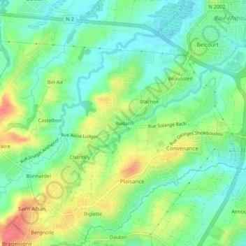
Name: Budan topographic map, elevation, terrain.
Location: Budan, Baie-Mahault, Basse-Terre, Guadeloupe, 97122, France (16.22275 -61.62910 16.26275 -61.58910)
Average elevation: 95 ft
Minimum elevation: 13 ft
Maximum elevation: 226 ft
Thank you for supporting this site ❤️
Make a donation
Make a donation
Gear up for your next adventure:
As an Amazon Associate, this site earns from qualifying purchases at no extra cost to you.