
Thank you for supporting this site ❤️
Make a donation
Make a donation
Gear up for your next adventure:
As an Amazon Associate, this site earns from qualifying purchases at no extra cost to you.
Marktgemeinde Rum topographic map
Click on the map to display elevation.
Thank you for supporting this site ❤️
Make a donation
Make a donation
Gear up for your next adventure:
As an Amazon Associate, this site earns from qualifying purchases at no extra cost to you.
About this map
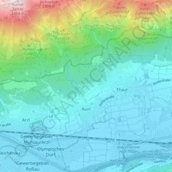
Name: Marktgemeinde Rum topographic map, elevation, terrain.
Location: Marktgemeinde Rum, Bezirk Innsbruck-Land, Tyrol, 6063, Austria (47.26713 11.39969 47.32057 11.46658)
Average elevation: 2,979 ft
Minimum elevation: 1,827 ft
Maximum elevation: 7,933 ft
Thank you for supporting this site ❤️
Make a donation
Make a donation
Gear up for your next adventure:
As an Amazon Associate, this site earns from qualifying purchases at no extra cost to you.