Geolocate

Hormuz topographic map

Click on the map to display elevation.

About this map

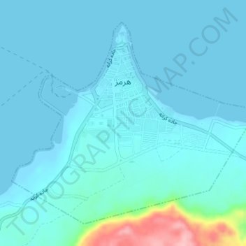
Name: Hormuz topographic map, elevation, terrain.

Location: Hormuz, بخش هرمز, Qeshm County, Hormozgan Province, Iran (27.07705 56.43654 27.10309 56.47224)

Average elevation: 56 ft

Minimum elevation: -3 ft

Maximum elevation: 505 ft

Other topographic maps

Click on a map to view its topography, its elevation and its terrain.

Gear up for your next adventure:

📱Heavy-Duty Phone Cases - Drop-proof and waterproof protection for outdoor navigation
🧭Pro Hiking Compasses - High-accuracy liquid-filled compasses for topographic orientation
🎒Trekking Poles - Sturdy poles for balance and stability on rough terrain
🛡️Insect Repellent - Protection against bugs during outdoor activities
🛰️Satellite Messengers - Emergency SOS and two-way messaging for off-grid adventures

As an Amazon Associate, this site earns from qualifying purchases at no extra cost to you.