
Make a donation
Gear up for your next adventure:
As an Amazon Associate, this site earns from qualifying purchases at no extra cost to you.
Suchu topographic map
Click on the map to display elevation.
Make a donation
Gear up for your next adventure:
As an Amazon Associate, this site earns from qualifying purchases at no extra cost to you.
About this map
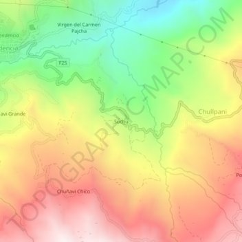
Name: Suchu topographic map, elevation, terrain.
Location: Suchu, Municipio Ayopaya, Ayopaya, Cochabamba, Bolivien (-17.11631 -66.81771 -17.07631 -66.77771)
Average elevation: 9,383 ft
Minimum elevation: 7,680 ft
Maximum elevation: 11,017 ft
Make a donation
Gear up for your next adventure:
As an Amazon Associate, this site earns from qualifying purchases at no extra cost to you.
Other topographic maps
Click on a map to view its topography, its elevation and its terrain.
Río Sacambaya
Bolivien > Cochabamba > Ayopaya > Municipio Ayopaya
Der Río Sacambaya bildet sich am Ostrand der Kordillere Quimsa Cruz aus der Vereinigung des Río Ayopaya mit dem Río Ichoca-Colquiri in einer Höhe von 1734 m. Der Fluss fließt ab seiner Entstehung in nordöstlicher Richtung und bildet nach 37 Kilometern zusammen mit dem von rechts einmündenden Río Negro…
Average elevation: 8,973 ft