Geolocate

Dufftown topographic map

Interactive map

Click on the map to display elevation.

About this map

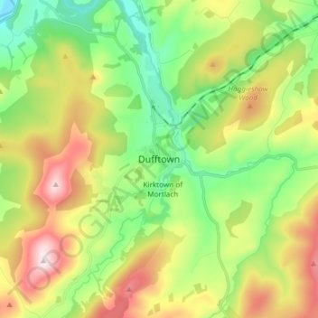
Name: Dufftown topographic map, elevation, terrain.

Location: Dufftown, Moray, Scotland, AB55 4AD, United Kingdom (57.40490 -3.16835 57.48490 -3.08835)

Average elevation: 879 ft

Minimum elevation: 259 ft

Maximum elevation: 1,860 ft

Other topographic maps

Click on a map to view its topography, its elevation and its terrain.

Glenlivet

United Kingdom > Scotland > Moray

Glenlivet, Moray, Scotland, AB37 9BT, United Kingdom

Average elevation: 919 ft

Spey Bay

United Kingdom > Scotland > Moray

Spey Bay, Moray, Scotland, IV32 7RR, United Kingdom

Average elevation: 16 ft

Longmorn

United Kingdom > Scotland > Moray > Longmorn

Longmorn, Moray, Scotland, IV30 8SA, United Kingdom

Average elevation: 220 ft

Dallas

United Kingdom > Scotland > Moray

Dallas, Moray, Scotland, IV36 2SA, United Kingdom

Average elevation: 673 ft

Ballindalloch

United Kingdom > Scotland > Moray > Ballindalloch

Ballindalloch, Moray, Scotland, AB37 9YF, United Kingdom

Average elevation: 764 ft

Forres

United Kingdom > Scotland > Moray > Forres

Forres, Moray, Scotland, IV36 1NX, United Kingdom

Average elevation: 102 ft

Kinloss

United Kingdom > Scotland > Moray

Kinloss, Moray, Scotland, IV36 3UT, United Kingdom

Average elevation: 33 ft