
Make a donation
Gear up for your next adventure:
As an Amazon Associate, this site earns from qualifying purchases at no extra cost to you.
Gadahinglaj topographic map
Click on the map to display elevation.
Make a donation
Gear up for your next adventure:
As an Amazon Associate, this site earns from qualifying purchases at no extra cost to you.
Gadahinglaj
Gadhinglaj is situated on the banks of the Hiranyakeshi river, which originates in the Amboli Ghats mountains. It is located at the border between Maharashtra and Karnataka. Maharashtra State Highway 134 passes through the city. Gadinglaj is the headquarters of South Kolhapur and a sub-district of the Kolhapur District. It is the largest city in South Kolhapur and has enough area and population to be deemed a district. The city is at an average elevation of 623 metres (2,044 ft).
Make a donation
Gear up for your next adventure:
As an Amazon Associate, this site earns from qualifying purchases at no extra cost to you.
About this map
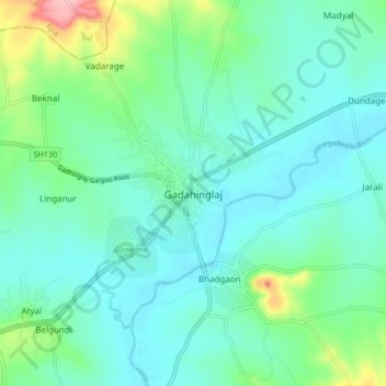
Name: Gadahinglaj topographic map, elevation, terrain.
Location: Gadahinglaj, Gadhinglaj, Kolhapur, Maharashtra, 416502, India (16.18369 74.31159 16.26369 74.39159)
Average elevation: 2,149 ft
Minimum elevation: 2,047 ft
Maximum elevation: 2,536 ft
Make a donation
Gear up for your next adventure:
As an Amazon Associate, this site earns from qualifying purchases at no extra cost to you.
Other topographic maps
Click on a map to view its topography, its elevation and its terrain.