Geolocate

Brigg topographic map

Click on the map to display elevation.

About this map

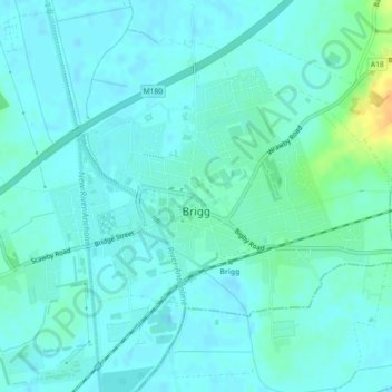
Name: Brigg topographic map, elevation, terrain.

Location: Brigg, North Lincolnshire, England, United Kingdom (53.54212 -0.50317 53.56504 -0.46671)

Average elevation: 20 ft

Minimum elevation: -3 ft

Maximum elevation: 95 ft

Other topographic maps

Click on a map to view its topography, its elevation and its terrain.

Messingham

United Kingdom > England > North Lincolnshire

Average elevation: 56 ft

Gear up for your next adventure:

🎒Trekking Poles - Sturdy poles for balance and stability on rough terrain
🗺️Topographic Maps - Detailed topo maps for hiking, exploring and outdoor navigation
Backpacking Tent - Lightweight and durable tent for multi‑day hikes
🔭Compact Binoculars - HD vision for scouting terrain and identifying distant landmarks
🕶️GPS Smartphone Mount - Secure mount for phone navigation

As an Amazon Associate, this site earns from qualifying purchases at no extra cost to you.