Geolocate

Willington topographic map

Click on the map to display elevation.

About this map

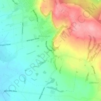
Name: Willington topographic map, elevation, terrain.

Location: Willington, Cheshire West and Chester, England, United Kingdom (53.18087 -2.72016 53.20309 -2.67533)

Average elevation: 282 ft

Minimum elevation: 112 ft

Maximum elevation: 571 ft

Gear up for your next adventure:

🪶Fire Starter Kit - Reliable fire starter for survival and camping
🔪Outdoor Multitools - Essential survival tools for gear repair and field use
🔋Rechargeable Batteries - Power up your outdoor devices
GPS Sports Watch - GPS watch for running, hiking and training
📱Solar Portable Charger - Solar power bank for charging devices off‑grid

As an Amazon Associate, this site earns from qualifying purchases at no extra cost to you.