Geolocate

Weipa topographic map

Click on the map to display elevation.

About this map

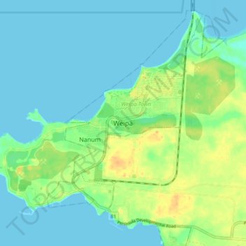
Name: Weipa topographic map, elevation, terrain.

Location: Weipa, Weipa Town, Queensland, 4874, Australia (-12.67866 141.83109 -12.59866 141.91109)

Average elevation: 30 ft

Minimum elevation: -3 ft

Maximum elevation: 102 ft

Gear up for your next adventure:

📚Navigation Handbooks - Master the art of reading topographic maps and using a compass
😴Insulated Sleeping Pads - Compact and warm pads for high-elevation camping
🌡️Handheld Weather Meters - Measure wind, temp, and pressure for safe mountain travel
📡GPS Antenna Upgrade - Enhance GPS reception in remote terrain
🧭Compass with Lanyard - Easy‑carry compass for navigation

As an Amazon Associate, this site earns from qualifying purchases at no extra cost to you.