
Over topographic map
Click on the map to display elevation.
About this map
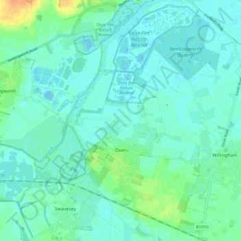
Name: Over topographic map, elevation, terrain.
Average elevation: 23 ft
Minimum elevation: -10 ft
Maximum elevation: 102 ft
Other topographic maps
Click on a map to view its topography, its elevation and its terrain.
Bassingbourn
United Kingdom > England > Cambridgeshire > South Cambridgeshire
Average elevation: 102 ft
Chittering
United Kingdom > England > Cambridgeshire > South Cambridgeshire > Waterbeach
Average elevation: 10 ft
Odsey
United Kingdom > England > Cambridgeshire > South Cambridgeshire > Steeple Morden
Average elevation: 269 ft
Great Chishill
United Kingdom > England > Cambridgeshire > South Cambridgeshire
Average elevation: 367 ft
Nine Wells
United Kingdom > England > Cambridgeshire > South Cambridgeshire > Great Shelford
Average elevation: 66 ft
Bourn Bridge
United Kingdom > England > Cambridgeshire > South Cambridgeshire > Little Abington
Average elevation: 128 ft
Little Linton
United Kingdom > England > Cambridgeshire > South Cambridgeshire > Linton
Average elevation: 203 ft
Hatley's Children's Pit
United Kingdom > England > Cambridgeshire > South Cambridgeshire > Landbeach
Average elevation: 23 ft
Westwick
United Kingdom > England > Cambridgeshire > South Cambridgeshire > Oakington > Westwick
Average elevation: 36 ft
Gamlingay Wood NR
United Kingdom > England > Cambridgeshire > South Cambridgeshire > Gamlingay
Average elevation: 184 ft
Hayley Wood NR
United Kingdom > England > Cambridgeshire > South Cambridgeshire > Hatley
Average elevation: 249 ft